![](/images/other/stat-length.png)
![Excursión Bici de montaña Les Baroches - rando vtt baroches , bettainviller ,baroche - Photo](https://media.geolcdn.com/t/1900/400/ext.pjpeg?maxdim=2&url=https%3A%2F%2Fstatic1.geolcdn.com%2Fsiteimages%2Fupload%2Ffiles%2F1524743154velo.jpg)
rando vtt baroches , bettainviller ,baroche
adventurer
Usuario
![Longitud](/images/other/stat-length.png)
Longitud
25 km
![Altitud máxima](https://static1.geolcdn.com/siteimages/upload/files/1508320355ic_sort_altitude_max_24dp.png)
Altitud máxima
286 m
![Desnivel positivo](https://static1.geolcdn.com/siteimages/upload/files/1508320355ic_sort_den_pos_24dp.png)
Desnivel positivo
319 m
![Km-Effort](/images/other/stat-length.png)
Km-Effort
29 km
![Altitud mínima](https://static1.geolcdn.com/siteimages/upload/files/1508320355ic_sort_altitude_min_24dp.png)
Altitud mínima
209 m
![Desnivel negativo](https://static1.geolcdn.com/siteimages/upload/files/1508320355ic_sort_den_neg_24dp.png)
Desnivel negativo
319 m
![Boucle](https://static1.geolcdn.com/siteimages/upload/files/16400158638029165_repeat_loop_refresh_sync_direction_icon.png)
Boucle
Sí
Fecha de creación :
2020-06-15 07:39:20.427
Última modificación :
2020-06-15 07:42:29.815
![Bici de montaña](https://static1.geolcdn.com/sitytour/trail-icons/202.png)
1h56
Dificultad : Medio
![Escanee este código QR para abrir la excursión en la aplicación SityTrail](https://capi.geolives.com/qq0zvz2zws4bq2lad0pu/sitytour/trails/2437047/qr.png?size=200)
Aplicación GPS de excursión GRATIS
A propósito
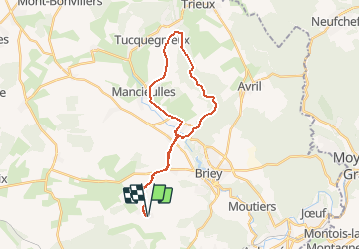
Ruta Bici de montaña de 25 km a descubrir en Gran Este, Meurthe y Mosela, Les Baroches. Esta ruta ha sido propuesta por adventurer.
Descripción
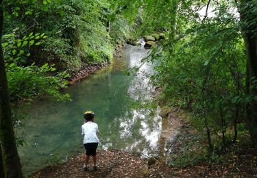
Rando VTT par la voie verte de Mance , passage en foret devant une résurgence , appeler le trou des fées , monter ensuite jusque Bettainviller par les bois , et retour vers les Baroches par la route .
Localización
País:
France
Región :
Gran Este
Departamento/provincia :
Meurthe y Mosela
Municipio :
Les Baroches
Localidad:
Unknown
Salida:(Dec)
Salida:(UTM)
710774 ; 5456962 (31U) N.
Comentarios
Excursiones cerca
![Excursión A pie Val de Briey - CV Haut Charme - Photo](https://media.geolcdn.com/t/375/260/4e9bdffd-7a79-4a02-9ca5-caf611bbbb83.jpeg&format=jpg&maxdim=2)
![A pie A pie](https://static1.geolcdn.com/sitytour/trail-icons/100.png)
CV Haut Charme
A pie
Fácil
Val de Briey,
Gran Este,
Meurthe y Mosela,
France
![](/images/other/stat-length.png)
11,1 km | 13,8 km-effort
3h 8min
![](https://static1.geolcdn.com/siteimages/upload/files/16400158638029165_repeat_loop_refresh_sync_direction_icon.png)
Sí
![Excursión Senderismo Val de Briey - Briey en famille - Photo](https://media.geolcdn.com/t/375/260/7a2bae71-a77e-4de9-b61c-c53dacb17e80.jpg&format=jpg&maxdim=2)
![Senderismo Senderismo](https://static1.geolcdn.com/sitytour/trail-icons/101.png)
Briey en famille
Senderismo
Fácil
Val de Briey,
Gran Este,
Meurthe y Mosela,
France
![](/images/other/stat-length.png)
8,1 km | 10,3 km-effort
2h 21min
![](https://static1.geolcdn.com/siteimages/upload/files/16400158638029165_repeat_loop_refresh_sync_direction_icon.png)
Sí
![Excursión Paseo ecuestre Val de Briey - Briey 1 - Photo](https://media.geolcdn.com/t/375/260/ext.jpg?maxdim=2&url=https%3A%2F%2Fstatic1.geolcdn.com%2Fsiteimages%2Fupload%2Ffiles%2F1524743154cheval.jpg)
![Paseo ecuestre Paseo ecuestre](https://static1.geolcdn.com/sitytour/trail-icons/301.png)
Briey 1
Paseo ecuestre
Fácil
Val de Briey,
Gran Este,
Meurthe y Mosela,
France
![](/images/other/stat-length.png)
9,2 km | 10,5 km-effort
1h 53min
![](https://static1.geolcdn.com/siteimages/upload/files/16400158638029165_repeat_loop_refresh_sync_direction_icon.png)
No
![Excursión Bici de montaña Valleroy - vallée de l'Orne - Photo](https://media.geolcdn.com/t/375/260/ext.jpg?maxdim=2&url=https%3A%2F%2Fstatic1.geolcdn.com%2Fsiteimages%2Fupload%2Ffiles%2F1524743154velo.jpg)
![Bici de montaña Bici de montaña](https://static1.geolcdn.com/sitytour/trail-icons/202.png)
vallée de l'Orne
Bici de montaña
Muy fácil
Valleroy,
Gran Este,
Meurthe y Mosela,
France
![](/images/other/stat-length.png)
21 km | 23 km-effort
2h 26min
![](https://static1.geolcdn.com/siteimages/upload/files/16400158638029165_repeat_loop_refresh_sync_direction_icon.png)
No
![Excursión A pie Val de Briey - Boucle de Mance - Photo](https://media.geolcdn.com/t/375/260/ext.jpg?maxdim=2&url=https%3A%2F%2Fstatic1.geolcdn.com%2Fsiteimages%2Fupload%2Ffiles%2F1545311037marcheuse_200dpi.jpg)
![A pie A pie](https://static1.geolcdn.com/sitytour/trail-icons/100.png)
Boucle de Mance
A pie
Fácil
Val de Briey,
Gran Este,
Meurthe y Mosela,
France
![](/images/other/stat-length.png)
10 km | 12,2 km-effort
2h 46min
![](https://static1.geolcdn.com/siteimages/upload/files/16400158638029165_repeat_loop_refresh_sync_direction_icon.png)
Sí
![Excursión Bici de montaña Les Baroches - VTT Baroche hatrize homecourt briey - Photo](https://media.geolcdn.com/t/375/260/ext.jpg?maxdim=2&url=https%3A%2F%2Fstatic1.geolcdn.com%2Fsiteimages%2Fupload%2Ffiles%2F1524743154velo.jpg)
![Bici de montaña Bici de montaña](https://static1.geolcdn.com/sitytour/trail-icons/202.png)
VTT Baroche hatrize homecourt briey
Bici de montaña
Difícil
Les Baroches,
Gran Este,
Meurthe y Mosela,
France
![](/images/other/stat-length.png)
44 km | 50 km-effort
3h 18min
![](https://static1.geolcdn.com/siteimages/upload/files/16400158638029165_repeat_loop_refresh_sync_direction_icon.png)
Sí
![Excursión Carrera Val de Briey - run matinal - Photo](https://media.geolcdn.com/t/375/260/ext.jpg?maxdim=2&url=https%3A%2F%2Fstatic1.geolcdn.com%2Fsiteimages%2Fupload%2Ffiles%2F1524743154running.jpg)
![Carrera Carrera](https://static1.geolcdn.com/sitytour/trail-icons/103.png)
run matinal
Carrera
Fácil
Val de Briey,
Gran Este,
Meurthe y Mosela,
France
![](/images/other/stat-length.png)
10,1 km | 13,6 km-effort
55min
![](https://static1.geolcdn.com/siteimages/upload/files/16400158638029165_repeat_loop_refresh_sync_direction_icon.png)
Sí
![Excursión Ruta Les Baroches - footing boiser - Photo](https://media.geolcdn.com/t/375/260/ext.jpg?maxdim=2&url=https%3A%2F%2Fstatic1.geolcdn.com%2Fsiteimages%2Fupload%2Ffiles%2F1524743154running.jpg)
![Ruta Ruta](https://static1.geolcdn.com/sitytour/trail-icons/104.png)
footing boiser
Ruta
Medio
Les Baroches,
Gran Este,
Meurthe y Mosela,
France
![](/images/other/stat-length.png)
11,2 km | 12,9 km-effort
1h 14min
![](https://static1.geolcdn.com/siteimages/upload/files/16400158638029165_repeat_loop_refresh_sync_direction_icon.png)
Sí
![Excursión Senderismo Les Baroches - rando baroches - Photo](https://media.geolcdn.com/t/375/260/ext.jpg?maxdim=2&url=https%3A%2F%2Fstatic1.geolcdn.com%2Fsiteimages%2Fupload%2Ffiles%2F1553511878bg_sport_marche.png)
![Senderismo Senderismo](https://static1.geolcdn.com/sitytour/trail-icons/101.png)
rando baroches
Senderismo
Fácil
Les Baroches,
Gran Este,
Meurthe y Mosela,
France
![](/images/other/stat-length.png)
11,2 km | 13,1 km-effort
1h 38min
![](https://static1.geolcdn.com/siteimages/upload/files/16400158638029165_repeat_loop_refresh_sync_direction_icon.png)
Sí